Business Details
38 Years
experience
Expert Land Surveying Services in New York City
Manhattan Surveying has established itself as a leader in delivering precise and efficient surveying solutions for over three decades. Our team combines 100+ years of collective experience with cutting-edge technology, including 3D laser scanning and High Definition Surveying (HDS), to tackle complex projects across the New York Metropolitan Area. We specialize in construction surveys, boundary determinations, and data collection for high-rise buildings, infrastructure, and culturally significant sites. Our commitment to safety aligns with OSHA guidelines, DOB regulations, and modern health protocols, ensuring seamless compliance for every project.With a repository of historical surveys dating back over a century, we provide unparalleled accuracy in title and boundary data, preventing potential issues before closing. Our collaborative approach with affiliated firms like Muoz Engineering allows us to offer end-to-end servicesfrom initial layout to final deliverableswhile maintaining the highest standards of professionalism and precision.
Services
Construction Survey
Laser Scanning
Profile Surveys
Monitoring Services
CADD Services
Details
- Year established: 1988
Highlights and features
- We offer 100+ years of combined experience in NYC's complex real estate landscape.
- Our 3D laser scanning technology reduces site visits and project costs.
- We maintain strict compliance with OSHA, DOB, and safety protocols.
- Our historical survey database prevents boundary/title issues before closing.
- We deliver tailored solutions for both public and private sector projects.
Services
3D Laser Scanning
Our 3D laser scanning creates detailed point clouds for accurate modeling of buildings, infrastructure, and landscapes. This technology enables precise measurements without repeated site visits, reducing costs and delays. Clients receive survey-grade data for BIM integration, structural analysis, and compliance verification.
Construction Surveying
We provide precise layout and stakeout services for new construction and rehabilitation projects. Our crews ensure alignment with design plans using advanced tools and historical data. Services include boundary verification, elevation checks, and as-built documentation to maintain project timelines and budgets.
Profile Surveys
Our profile surveys capture detailed terrain and structural features for infrastructure and development projects. Using LiDAR and traditional methods, we generate elevation models and cross-sections. These surveys support grading, drainage planning, and compliance with municipal regulations.
Monitoring Services
We monitor buildings and infrastructure for movement, settlement, or deformation using high-precision instruments. Regular data collection ensures early detection of potential issues, maintaining safety and compliance. Clients receive actionable insights for maintenance or remediation planning.
CADD Services
Our CADD team converts field data into detailed plans, sections, and 3D models using AutoCAD and Revit. Deliverables include floor plans, elevation drawings, and BIM-ready files. These digital assets support design coordination, permitting, and construction management workflows.
Questions
What types of projects do you specialize in?
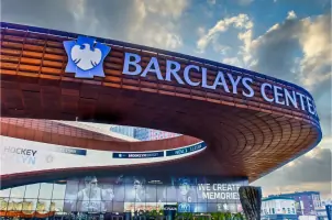
We specialize in high-rise buildings, infrastructure, stadiums, and complex urban developments across NYC.
How does 3D laser scanning benefit my project?
It reduces site visits, lowers costs, and provides survey-grade accuracy for BIM and design workflows.
Are you licensed to work in New York City?
Yes, we hold all required licenses and follow DOB regulations and OSHA safety standards.
Can you handle historical property surveys?
Our archive of 100+ year-old surveys ensures accurate boundary/title data for NYC properties.
How do you ensure project compliance?
We follow DOB rules, OSHA guidelines, and client-specific safety protocols throughout each project.