
Business Details
21 Years
experience
Expert Land Surveying Services in East TN & Western NC
Appalachian Surveying Consultants was established in 2005 to provide specialized land surveying and development planning services across East Tennessee and Western North Carolina. Our team combines over two decades of field experience with advanced GPS and CAD technologies to deliver precise boundary surveys, topographic mapping, and construction staking solutions. As active members of the National Society of Professional Surveyors and state associations, we maintain rigorous professional standards while offering personalized attention to every project. Our founder, a licensed surveyor in both Tennessee and North Carolina with certifications in floodplain surveying, personally oversees client engagements to ensure alignment with project goals.We emphasize transparency through free project quotes and maintain a track record of successful completion for over $1 billion in residential and commercial developments. Our technical expertise extends to FEMA elevation certifications, ALTA surveys, and comprehensive subdivision planning, supported by academic contributions as adjunct professors in geomatics programs. Client satisfaction is guaranteed through timely execution, meticulous documentation, and a deep understanding of regional terrain challenges in mountainous environments.
Services
Boundary Surveying
Topographic Mapping
Construction Staking
Site Planning
FEMA Elevation Certificates
ALTA Surveys
Subdivision Planning
Aerial Topographic Surveys
Mapping Services
Permit Assistance
Details
- Year established: 2005
Highlights and features
- We offer over 20 years of experience in land surveying and development planning
- Our founder personally oversees client engagements for project alignment
- We maintain dual state surveyor licenses in Tennessee and North Carolina
- Free project quotes provided for all residential and commercial surveys
- Guaranteed timely execution with meticulous documentation standards
Services
Boundary Surveying
We conduct precise boundary surveys for residential and commercial properties using advanced GPS technology. Our surveys identify property lines, easements, and encroachments to prevent legal disputes during real estate transactions or development projects. Clients receive detailed documentation meeting all state and federal standards.
Topographic Mapping
Our topographic surveys create detailed elevation models for site planning and construction projects. Using robotic total stations and GPS systems, we map natural features and man-made structures to support drainage planning, road design, and building placement in mountainous regions.
FEMA Elevation Certificates
Certified floodplain surveyors provide FEMA elevation certificates for properties in high-risk flood zones. We expedite LOMA applications and offer free flood risk analyses to help clients reduce insurance costs while meeting regulatory requirements for property development.
Construction Staking
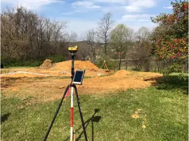
We establish precise reference points for residential and commercial construction projects. Our staking services guide grading, foundation placement, and utility installation using robotic total stations to ensure structures align perfectly with approved site plans.
Subdivision Planning
We design residential and commercial subdivisions including roadways, lot layouts, and erosion control plans. Our team coordinates with local governments to secure necessary permits and prepares final plats for recording, ensuring compliance with zoning regulations and environmental standards.
People
Mr. Bartlett
Founder & President
Licensed surveyor in Tennessee (#1984) and North Carolina (L-3593) with 30+ years experience. Holds AAS in Civil Engineering, certified floodplain surveyor (NC-065, TN-001), and former adjunct professor in geomatics programs. Managed $1B+ in development projects across the Southeast.
Questions
What geographic areas do you serve?
We specialize in land surveying projects throughout East Tennessee and Western North Carolina, including mountainous regions requiring specialized terrain analysis.
What types of surveys do you perform?
Our services include boundary surveys, topographic mapping, construction staking, FEMA elevation certificates, ALTA surveys, and subdivision planning for residential and commercial properties.
Are your surveyors licensed?
Yes, our founder holds active licenses in Tennessee (#1984) and North Carolina (L-3593) with additional certification as a floodplain surveyor in both states.
Do you offer free project estimates?
We provide complimentary quotes for all surveying projects, regardless of size, with no obligation to proceed with our services.
How do you handle regulatory permitting?
Our team prepares required documentation and coordinates directly with local government agencies to secure permits for land development projects.
What technology do you use?
We utilize GPS systems, robotic total stations, and computer-aided drafting software to ensure maximum accuracy and efficiency in all surveying operations.