Business Details
Expert Land Surveying & Development Services in Raleigh
Residential Land Services was founded on the principle of delivering precise and cost-effective land surveying solutions to North Carolina clients. Starting as a single surveyor in the Raleigh-Durham area, we have expanded to serve Greensboro, Fayetteville, and Greenville with multiple field crews. Our team combines cutting-edge technology with a commitment to exceptional customer service, ensuring every project meets the highest quality standards. We specialize in land surveying, civil/site design, and land development support tailored to meet the needs of developers, contractors, and homeowners. By continuously investing in advanced tools and hiring skilled professionals, we maintain our reputation as a trusted trade partner.Our focus remains on building long-term relationships through integrity, ethical practices, and timely project completion. With decades of collective experience, we address complex land development challenges while prioritizing client satisfaction. Our mission-driven approach ensures accuracy across services like boundary surveys, flood elevation certifications, and construction staking. As a locally rooted firm, we understand regional market demands and regulatory landscapes, enabling efficient project execution. Our dedication to innovation and client-centric service has solidified our position as a leader in North Carolina's surveying industry.

Services
Land Surveying
Boundary Surveys
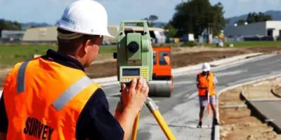
Construction Staking
Flood Certifications
Site Planning
Highlights and features
- We provide ISO 9001 certified surveying services with 20+ years of regional experience.
- Our team utilizes cutting-edge equipment for enhanced measurement accuracy.
- We guarantee timely project completion with personalized client communication.
- We offer comprehensive solutions covering all land development phases.
- Our staff includes licensed surveyors with advanced certifications in civil engineering.
Services
Land Surveying
Our land surveying services provide precise property boundary determinations using advanced GPS and total station equipment. We deliver accurate legal descriptions and plat maps for residential and commercial developments. Our surveys meet all North Carolina regulatory requirements for property transactions and construction projects.
Construction Staking
We offer construction staking services to establish exact building locations and elevations for new developments. Our team works closely with contractors to ensure proper alignment of foundations, utilities, and infrastructure. This service guarantees compliance with approved site plans and building permits.
Flood Elevation Certificates
Our flood elevation certificates document building elevations relative to flood risk zones for FEMA compliance. This service is essential for property owners seeking accurate flood insurance ratings and regulatory approvals in coastal and inland floodplain areas.
Topographical Surveys
We conduct detailed topographical surveys to create elevation models and terrain maps for land development projects. This service supports drainage planning, site design, and environmental impact assessments with precise elevation data and surface features.
ALTA Surveys
Our ALTA/ACSM land title surveys meet national standards for commercial property transactions. We identify boundary lines, easements, and improvements to support title insurance requirements. This service provides comprehensive documentation for lenders and property buyers.
Questions
What surveying services do you offer for residential properties?
We provide boundary surveys, flood elevation certificates, and site planning services for residential developments.
Do you serve areas outside the Raleigh-Durham region?
Yes, we serve Greensboro, Fayetteville, and Greenville in addition to the Raleigh-Durham Triangle area.
How do you ensure survey accuracy?
We use high-precision GPS equipment and robotic total stations operated by licensed professional surveyors.
What information is needed for a property survey?
We require property deeds, existing plats, and any recent construction plans to perform accurate boundary determinations.
How long does a typical survey take?
Most residential surveys are completed within 3-5 business days after scheduling confirmation.
Can you assist with commercial land development projects?
Yes, we offer comprehensive services including ALTA surveys, construction staking, and site planning for commercial developments.