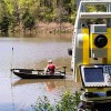
Land Surveying is the technique and science of accurately determining the terrestrial or three-dimensional space position of points and the distances and angles between them. These points are usually, but not exclusively, associated with positions on the surface of the Earth, and are often used to establish land maps and boundaries for ownership or governmental purposes.* Origin Land Surveying and Mapping, Inc. has been performing 3D laser scanning and spatial imaging services since 2007. All of our scanning services as well as our data reduction is performed by a licensed Professional Land Surveyor (PLS).
Similar Businesses

Gray Surveying
Lincolnton NC (14.1 mi)

GPA Land Surveying
Charlotte NC (17.5 mi)

Lucas-Forman
Charlotte NC (17.6 mi)

The Isaacs Group
Charlotte NC (17.8 mi)

Carter Land Surveyors
Charlotte NC (18 mi)

Taylor Wiseman & Taylor
Charlotte NC (18.3 mi)
Ldsi
Charlotte NC (19.3 mi)

Donaldson Garrett & Associates
Charlotte NC (19.4 mi)