
Business Details
Expert Land Surveying Services in Huntsville, AL
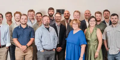
Halliburton Surveying & Mapping has established itself as a trusted provider of comprehensive surveying solutions since its founding. With decades of combined experience across our team of licensed professionals, we specialize in delivering precise and reliable services tailored to meet the unique demands of diverse industries. Our expertise spans land surveying, advanced 3D laser scanning, Aerial LiDAR, utility locating, and deformation monitoring, supported by cutting-edge technology and rigorous safety standards.Licensed in Alabama, Mississippi, Tennessee, and Georgia, we serve federal, state, municipal, healthcare, industrial, and residential sectors, prioritizing client satisfaction through technical excellence and personalized service. Recognized for innovation and quality, we maintain industry certifications and awards, including multiple Associated Builders & Contractors Diamond Level STEP Awards, underscoring our commitment to professionalism and trustworthiness.


Services
Land Surveying
LiDAR/Laser Scanning
Mapping Services
Deformation Monitoring
Utility Mapping/GPR
Highlights and features
- We offer 30+ years of specialized land surveying experience in the Southeast.
- Our team includes four licensed land surveyors and FAA-certified drone pilots.
- We utilize advanced 3D laser scanning and LiDAR technology for accuracy.
- Safety-certified staff with OSHA30, CPR/AED, and MSHA certifications.
- Award-winning service with six consecutive ABC Diamond Level STEP Awards.
What people say
High-resolution maps essential for hunting
Accurate utility locating
Award-winning safety standards
Advanced LiDAR technology
Experienced licensed professionals
Services
Land Surveying
Our land surveying services encompass boundary determination, topographic mapping, and construction staking for residential, commercial, and industrial projects. Using GPS and robotic total stations, we deliver precise measurements for legal and engineering purposes. Clients benefit from our licensed surveyors' deep regional expertise and compliance with state-specific standards.
LiDAR/Laser Scanning
LiDAR and laser scanning create detailed 3D models of structures and terrain for engineering and construction applications. Our equipment captures billions of data points, enabling virtual site analysis and reducing field time. This technology supports faster decision-making and cost savings for complex infrastructure projects.
Deformation Monitoring
Deformation monitoring tracks structural movements to ensure safety and integrity for buildings, bridges, and industrial facilities. We deploy automated systems for real-time data collection and analysis. Clients receive early warnings of potential issues, preventing costly failures in critical infrastructure.
Utility Mapping/GPR
Utility mapping uses ground-penetrating radar to identify buried pipes, cables, and infrastructure for construction planning. Our NULCA-certified locators combine GPR with municipal records for accurate subsurface data. This minimizes excavation risks and ensures compliance with safety regulations.
Mapping Services
Custom mapping services produce detailed representations of properties for planning, development, and regulatory submissions. We create scaled plans for auction exhibits, environmental assessments, and municipal projects. Clients receive tailored visual tools that simplify complex spatial information.
People
Troy Halliburton
CEO & Principal Land Surveyor
Troy Halliburton, CEO and Principal Land Surveyor, holds a BS in Land Surveying from East Tennessee State University. With 30 years of experience across the Southeast, he is licensed in Alabama and Tennessee and leads the Alabama Society of Professional Land Surveyors.
Rusty Blackwell
COO & Partner
Rusty Blackwell, COO and Partner, brings expertise from large multidisciplinary firms to HSM. Licensed in Alabama, he serves on the Alabama Underground Damage Prevention Authority and drives technological innovation and business development initiatives.
Questions
What surveying services does Halliburton offer?
We provide land surveying, LiDAR scanning, deformation monitoring, utility mapping, and custom cartography for diverse industries.
Which states do you operate in?
We are licensed in Alabama, Mississippi, Tennessee, and Georgia, serving clients across the Southeastern United States.
How does your LiDAR technology benefit projects?
LiDAR reduces field time by 40-60% through rapid data collection, improving accuracy and cost-efficiency for complex sites.
Are your team members certified?
Yes, our staff includes OSHA30, CPR/AED, and MSHA-certified professionals, with six consecutive ABC safety awards.
Can you handle federal government projects?
Yes, we've completed work at Redstone Arsenal, Arnold Air Force Base, and NASA facilities with security-compliant protocols.
What industries do you specialize in?
We serve automotive, healthcare, municipal, industrial, and residential sectors with tailored surveying solutions.