Business Details
50+ Years
experience
Expert Land Surveying & Civil Engineering Services in Vernal, UT
Founded in 1964, Uintah Engineering & Land Surveying (UELS) has established itself as a leading provider of land surveying, civil engineering design, permitting, and GIS/mapping services across the Intermountain West. Our team of dedicated professionals brings decades of combined experience to deliver tailored solutions for energy markets including oil and gas, renewables, and power transmission. We prioritize client satisfaction through a commitment to quality, integrity, and innovation, leveraging advanced technologies like UAVs and LiDAR to enhance project accuracy. With a proven track record of managing thousands of projects, we ensure compliance with all regulatory standards while maintaining open communication with clients throughout every phase. Our safety-first culture and investment in continuous training for our staff underscore our dedication to excellence.Headquartered in Vernal, Utah, we serve clients across 22 states, offering comprehensive services that streamline project execution from initial planning to final delivery. Our client-centric approach ensures customized solutions that meet unique project requirements, supported by competitive pricing and transparent operations. With extensive experience in both remote and developed environments, we specialize in overcoming complex challenges to deliver timely, cost-effective results. Our long-standing relationships with regulatory agencies and focus on sustainable practices further distinguish us as industry leaders committed to exceeding client expectations.
Services
Land Surveying
Civil Engineering Design
Permitting
UAV and Drones
GIS and Mapping
Details
- Year established: 1964
Highlights and features
- We offer 60+ years of experience in energy sector surveying and engineering.
- Our FAA-licensed UAV pilots utilize cutting-edge drone technology for superior data accuracy.
- We provide end-to-end services across 22 states, from permitting to project completion.
- Our safety-first culture maintains an excellent fieldwork safety record.
- We combine competitive pricing with transparent operations and client-focused solutions.
Associations and certifications
- FAA (Federal Aviation Administration)
Services
Land Surveying
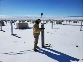
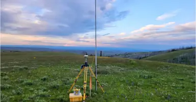
Our FAA-certified UAV teams conduct precise land surveys for projects ranging from residential lots to thousands of acres. Using drone photogrammetry and LiDAR, we deliver high-resolution data that reduces time and costs compared to traditional methods. Clients receive detailed orthomosaic images, digital terrain models, and ALTA surveys to support construction, energy development, and infrastructure projects.
Civil Engineering Design
We design grading plans, roadways, stormwater systems, and structural components for energy and municipal projects. Our engineers create specifications and construction documents compliant with BLM, Forest Service, and tribal regulations. Services include 3D modeling, floodplain analysis, and production water treatment systems to ensure functional, sustainable infrastructure solutions.
Permitting
Our specialists manage permitting processes for oil and gas, pipeline, and renewable energy projects across the Rocky Mountain region. We prepare applications for permits to drill, special use permits, and right-of-way agreements while maintaining compliance with evolving federal and state regulations. Project managers coordinate with agencies to streamline approvals and ensure operational compliance.
UAV and Drones
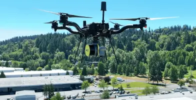
We deploy FAA-licensed drone pilots to capture aerial imagery, LiDAR data, and construction progress metrics. Services include power line inspections, corridor mapping, and stockpile measurements that enhance project monitoring. Our UAV technology provides accurate as-built documentation and topographic surveys to support engineering and surveying needs.
GIS and Mapping
Our GIS experts maintain client geodatabases and produce shapefiles, KMZ files, and ECMS-compliant maps. We offer asset management solutions, facility infrastructure mapping, and custom feature code libraries to organize spatial data. Services support permitting, pipeline routing, and environmental compliance through web-based platforms and detailed digital mapping.
People
Tracy Henline
CEO/President
With decades of leadership in engineering and land surveying, Tracy Henline drives UELS' strategic growth while maintaining its founding commitment to client-focused service and technical excellence across energy markets.
Tim Pierce
EVP/CFO
Tim Pierce oversees financial operations and corporate strategy, ensuring UELS maintains fiscal discipline while investing in cutting-edge technologies and staff development programs for long-term client value.
Harold Marshall
EVP/HSE/Engineering VP
Harold Marshall leads health, safety, and engineering initiatives, implementing rigorous safety protocols and technical standards that ensure compliance and excellence in every UELS project execution.
Zack Herbert
Director of Business Development
Zack Herbert builds strategic partnerships and expands UELS' market reach, leveraging deep industry knowledge to connect clients with tailored surveying, engineering, and permitting solutions.
Brandon Bowthorpe
Western/Southern Regional Manager
Brandon Bowthorpe manages regional operations across key energy markets, ensuring field teams deliver precise surveying and engineering services while maintaining UELS' safety and quality standards.
Questions
What industries does Uintah Engineering & Land Surveying serve?
We specialize in energy markets including oil and gas, renewables (wind and solar), power transmission, and land development projects across 22 western U.S. states.
How does UELS utilize drone technology?
Our FAA-licensed pilots use UAVs with LiDAR and photogrammetry to create high-resolution maps, monitor construction progress, and conduct pipeline routing surveys for faster, more accurate data collection.
What permitting services do you offer?
We manage regulatory compliance for energy projects, including APD applications, special use permits, right-of-way agreements, and environmental compliance documentation across federal and state jurisdictions.
What geographic areas do you cover?
We operate in 22 states across the Intermountain West, including Utah, Colorado, Wyoming, Texas, New Mexico, Montana, and all surrounding energy-producing regions.
How does UELS ensure project safety?
We maintain an excellent safety record through daily check-ins, equipment inspections, and mandatory training programs while equipping field crews with GPS tracking and emergency response tools.
What civil engineering services are available?
Our engineers design roadways, stormwater systems, structural components, and municipal infrastructure with 3D modeling, floodplain analysis, and construction management services for energy and industrial clients.