
Business Details
33 Years
experience
Professional Land Surveying Services in St. Louis, MO
At Sabur Surveying, Inc., our mission is to deliver accurate, professional land surveying services that meet the project objectives of our clients while maintaining timeliness and precision. Established in 1993, we specialize in boundary surveys, topographic surveys, and right-of-way surveys, supporting infrastructure projects such as roadways, municipal sewer systems, bridges, and commercial developments. Our services include preparing preliminary plans, assembling critical data like FEMA flood information and USGS maps, and creating plot plans for residential and commercial construction. We prioritize collaboration with clients, leveraging advanced technologies like GPS and GIS for large-scale utility mapping and aerial survey control.Our team has built lasting relationships with engineers, architects, contractors, and government agencies, serving Missouri and Eastern Illinois for over 30 years. Community involvement remains central to our values, exemplified by early partnerships with Habitat for Humanity and ongoing contributions to local redevelopment projects. We distinguish ourselves through expertise in both distressed community projects and complex infrastructure work, including heavy highway and bridge construction. Our commitment to employee development ensures high standards in land surveying, benefiting all clients. With offices two miles west of the I-170/Page intersection, we provide tailored solutions for diverse industries and landowners.
Services
Boundary Surveys
Topographic Surveys
Construction Stakeout
ALTA/ACSM Surveys
FEMA Flood Data
Plot Plans
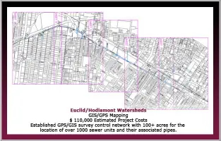
Utility Mapping
Elevation Certificates
Deed Plotting
GPS Surveys
Details
- Year established: 1993
Highlights and features
- We have over 30 years of experience in professional land surveying.
- Our team uses advanced GPS and GIS technologies for accurate data collection.
- We specialize in complex infrastructure projects, including highways and bridges.
- Our multi-lot survey program reduces costs for residential and commercial clients.
- We maintain long-term partnerships with government agencies and engineering firms.
Services
Boundary Surveys
We conduct precise boundary surveys to define property lines using legal documents, field data, and historical records. Our surveys resolve disputes, support real estate transactions, and ensure compliance with municipal regulations. Clients include homeowners, developers, and government agencies.
Topographic Surveys
Our topographic surveys map natural and man-made features, including elevation changes, vegetation, and structures. This data supports construction planning, environmental assessments, and infrastructure design. We use advanced tools like GPS and aerial control for accuracy.
Construction Stakeout
We provide construction stakeout services to mark precise locations for buildings, roads, and utilities. Our work ensures projects adhere to design plans, reducing errors and rework. Clients rely on us for commercial, municipal, and transportation projects.
ALTA/ACSM Surveys
ALTA/ACSM surveys meet national standards for property assessments, including easements, encroachments, and legal descriptions. These surveys are critical for commercial real estate transactions and title insurance requirements.
FEMA Flood Data
We supply FEMA-compliant flood data to determine flood zones and risks for properties. This information supports insurance requirements, development permits, and mitigation planning in flood-prone areas.
People
Mike Sater
Co-Founder
Mike Sater co-founded Sabur Surveying, Inc. in 1993 after working with Duane Burrell at a civil engineering firm. He focuses on client collaboration and technical excellence in land surveying projects.
Duane Burrell
Co-Founder
Duane Burrell transitioned from field surveying to office calculations before co-founding Sabur Surveying, Inc. He emphasizes employee development and precision in surveying methodologies.
Questions
What services does Sabur Surveying, Inc. offer?
We specialize in boundary surveys, topographic mapping, construction stakeout, ALTA/ACSM surveys, FEMA flood data, and legal property descriptions.
Which areas do you serve?
We serve Missouri and Eastern Illinois, with a focus on the St. Louis metropolitan area.
How long has Sabur Surveying, Inc. been in business?
We have provided land surveying services since our founding in 1993.
Can Sabur Surveying assist with multi-lot surveys?
Yes, our Multi-Lot Survey Program reduces costs and improves accuracy for neighborhood and commercial developments.
What technologies do you use?
We employ GPS, GIS, and aerial survey control for precise data collection and mapping.
Do you work with government agencies?
Yes, we collaborate with municipal, county, and state agencies on infrastructure and redevelopment projects.