Business Details
39 Years
experience
Professional Land Surveying Services in Denton, TX
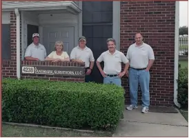
Since 1987, our team has delivered over 18,000 land surveys across Denton County, prioritizing client needs through timely service, competitive pricing, and technical precision. Our staff combines decades of field experience with advanced certifications, including Registered Professional Land Surveyor credentials, to address complex property challenges. We specialize in boundary determinations, flood insurance documentation, and municipal compliance, serving residential, commercial, and governmental clients. Our commitment to integrity ensures accurate data protection for property investments. With expertise spanning California, Illinois, and Texas, we provide localized insights backed by international project experience.Our office team maintains transparent communication throughout each project lifecycle. We adhere to strict licensing standards under Texas License #10098600, ensuring regulatory compliance for all survey types. Our technical staff holds advanced degrees in civil engineering and geography, maintaining industry-specific proficiencies. We invest in modern equipment and software to guarantee measurement accuracy within statutory requirements. Client education remains central to our process, explaining survey implications for property transactions and insurance needs.
Services
Mortgage Surveys
Topographic Surveys
FEMA Elevation Certificates
Subdivision Plats
Property Dispute Surveys
Construction Staking
ALTA/ASCM Surveys
Zoning Case Surveys
Drainage Surveys
Tree Surveys
Details
- Year established: 1987
Highlights and features
- We have performed over 18,000 surveys since 1987 in Denton County
- Our staff includes Registered Professional Land Surveyors with international experience
- We maintain Texas License #10098600 with strict compliance standards
- Our team holds technical degrees in civil engineering and geography
- We provide FEMA-certified elevation certificates for flood insurance requirements
Services
FEMA Elevation Certificates
Our FEMA-certified elevation certificates determine flood risk zones for insurance requirements. This service helps homeowners potentially reduce or eliminate mandatory flood insurance costs through official documentation. Surveys meet federal standards for accuracy and regulatory compliance.
Subdivision Plats
We create detailed subdivision plats for property development projects. Our surveys ensure compliance with municipal zoning regulations and infrastructure requirements. This service supports residential and commercial land division processes with precise boundary mapping.
Property Dispute Surveys
Our boundary surveys resolve property line conflicts through historical record analysis and physical marker verification. We provide expert testimony and documentation for legal proceedings. This service protects property investments against encroachment issues.
ALTA/ASCM Surveys
We conduct ALTA-compliant surveys for commercial property transactions. These comprehensive assessments identify easements, improvements, and encroachments affecting title insurance. Our surveys meet American Land Title Association standards for due diligence.
Construction Staking
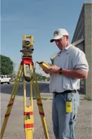
Our construction staking services establish precise building locations using digital mapping technology. We ensure structures align with approved plans and zoning requirements. This service supports accurate grading and foundation placement for development projects.
People
Jerald Yensan
President
Registered Professional Land Surveyor with 60+ years experience across three countries. Holds degrees from Moody Bible Institute and Monterey Peninsula College. Leads technical operations and client relations.
Steven Billmeier
Field Technician
Certified CADD technician with 30+ years local experience. Bachelor's degree in Industrial Technology from Tarleton State University. Specializes in field data collection and mapping.
Bradley Hamilton
CADD Technician
Geography graduate with urban planning expertise. 25+ years experience in Denton County surveying. Manages digital mapping and plat preparation.
Kyle Whitley
Field Technician
Former professional baseball pitcher turned surveyor. 20+ years field experience. Combines athletic precision with technical surveying skills for accurate data collection.
Vicky Carter
Office Manager
Former FEMA Natural Hazards Program Specialist with 14 years federal experience. Manages administrative operations and client communications.
Questions
Why do I need a new survey when buying a home?
Old surveys may have expired or missed recent changes like updated flood maps. We verify current property boundaries and easements to prevent future disputes.
How can a survey help with flood insurance costs?
Our FEMA-certified elevation certificates document your property's flood risk status. This documentation can potentially reduce or eliminate mandatory flood insurance requirements.
What survey types do you offer?
We provide boundary surveys, topographic maps, subdivision plats, construction staking, ALTA/ASCM surveys, and FEMA elevation certificates for residential and commercial properties.
How long does a typical survey take?
Most residential surveys complete within 3-5 business days after scheduling. Complex commercial projects require additional time based on property size and scope.
Are your surveys legally recognized?
Yes, our surveys meet Texas licensing standards and federal requirements. We maintain Texas License #10098600 with documentation accepted by banks, insurers, and government agencies.
What payment methods do you accept?
We accept credit card payments through PayPal for all services. Cash and checks also accepted for local clients with prior arrangements.