
Business Details
13 Years
experience
Expert Geospatial Services for Land Surveying, GIS, LiDAR & Utility Locating
Founded in 2013, GIS Surveyors has established itself as a trusted leader in geospatial services, combining cutting-edge technology with decades of collective expertise. As a service-disabled veteran-owned and employee-owned firm, we prioritize fiscal responsibility, exceptional customer service, and a client-first mindset to deliver innovative solutions. Our team of certified GIS professionals, licensed surveyors, and remote sensing experts brings unparalleled precision to land surveying, LiDAR, GIS, and utility locating projects nationwide.We distinguish ourselves through our commitment to excellence, fostering a culture that values diverse perspectives and technical mastery. With headquarters in San Diego and offices in Seattle, Cincinnati, and Los Angeles, we serve federal, state, and private clients across critical infrastructure sectors. Our Employee Stock Ownership Plan ensures long-term alignment with client success while maintaining the agility to adapt to evolving industry demands.


Services
Land Survey
GIS
LiDAR
Utility Locating
Federal Capabilities
Details
- Year established: 2013
Highlights and features
- We are a certified Service-Disabled Veteran-Owned Small Business with federal contracting expertise
- Our employee-owned structure ensures long-term commitment to project excellence
- We combine 30+ years of collective experience in geospatial technologies with certified professionals
- We maintain state-of-the-art capabilities in LiDAR, GIS, and underground utility detection
- Our nationwide presence includes offices in San Diego, Seattle, and Cincinnati
Associations and certifications
- Service-Disabled Veteran-Owned Small Business (SDVOSB)
- Disabled Veteran Business Enterprise (DVBE)
Services
Land Survey
Our licensed land surveyors utilize traditional and modern techniques including UAS drones for topographic surveys, construction staking, and as-built documentation. Clients benefit from FAA-certified pilots and mapping experts who ensure regulatory compliance and millimeter-level accuracy. This service supports infrastructure development, property boundary determination, and engineering projects across diverse terrains.
GIS
From basic mapping to complex geodatabase design, our GIS specialists transform spatial data into actionable insights. We offer data conversion, 3D modeling, and web-based mapping solutions that help clients visualize infrastructure networks, environmental patterns, and urban planning scenarios. Our FME/ETL workflows ensure seamless integration with existing systems and regulatory reporting requirements.
LiDAR
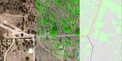
We deploy airborne, mobile, and terrestrial LiDAR systems to create high-resolution topographic models for engineering and environmental applications. Our experts perform feature extraction, vegetation analysis, and hydrologic modeling that support pipeline safety assessments, wildfire mitigation planning, and infrastructure asset management with sub-centimeter precision.
Utility Locating
Using ground-penetrating radar and radio locators, we identify underground utilities with industry-leading accuracy. Our S.U.E. engineering support includes conflict mapping, CCTV inspections, and 811 mark-out verification that prevent costly construction delays. Clients receive integrated survey data showing both surface and subsurface infrastructure in a single deliverable.
Federal Capabilities
As a certified SDVOSB, we specialize in federal infrastructure projects requiring GIS and LiDAR expertise. Our team supports water, energy, and transportation initiatives with ASCE-compliant surveying standards. We maintain active security clearances and follow DFARS compliance protocols for sensitive defense-related mapping and utility locating projects.
Questions
What geospatial services does GIS Surveyors offer?
We provide land surveying, GIS mapping, LiDAR scanning, and underground utility locating services for public works, energy, and infrastructure projects nationwide.
Is GIS Surveyors a certified veteran-owned business?
Yes, we are a Service-Disabled Veteran-Owned Small Business (SDVOSB) and Disabled Veteran Business Enterprise (DVBE) certified by the federal government.
What makes GIS Surveyors different from other surveying firms?
Our unique combination of veteran leadership, employee ownership, and technical expertise in four core geospatial disciplines enables comprehensive project solutions.
Which industries does GIS Surveyors support?
We serve energy, transportation, water/wastewater, and public works sectors with specialized capabilities for federal government contracts.
Where does GIS Surveyors operate?
Headquartered in San Diego with regional offices in Seattle and Cincinnati, we deliver projects nationwide with local market expertise.
Videos