Business Details
42 Years
experience
Precision Land Surveying Services in Lynden, WA
Northwest Surveying & GPS is a full-service land surveying company founded in 1984 by Denny DeMeyer, a lifelong Whatcom County native with deep roots in the community. Our team combines over 37 years of local experience with cutting-edge technology to deliver precise and reliable surveying solutions across the Pacific Northwest. We specialize in boundary surveys, subdivisions, construction staking, and environmental mapping, having completed over 3,300 Record of Surveys and 250 Short Plats in Whatcom County alone. Our approach emphasizes clear communication, project-specific expertise, and a commitment to meeting client needs efficiently. Led by Jeromy DeMeyer, who continues his father's legacy, we maintain a hands-on approach to every project, ensuring quality results that meet industry standards.Our dedication to ethical practices, technical excellence, and client satisfaction has made us a trusted partner for both public and private sector clients. We invest in ongoing professional development and the latest surveying tools to maintain our position as a leader in the field. From initial planning to final deliverables, our team works collaboratively with clients to navigate complex regulatory requirements and technical challenges. Our extensive local knowledge and long-standing relationships with municipal agencies streamline project approvals and implementation. Whether supporting large-scale infrastructure projects or individual property needs, we prioritize accuracy, timeliness, and transparent communication throughout every engagement.
Services
Boundary Surveys
Short Subdivisions
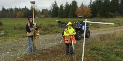
Construction Staking
Topographic Surveys
ALTA Surveys
Hydrographic Surveys
Lot Reconfigurations
Gravel Pit Reclamation
Easement Preparation
Wetland Mapping
Details
- Year established: 1984
Highlights and features
- 37 years of local Whatcom County surveying expertise
- Completed 3,300+ Record of Surveys and 250+ Short Plats
- Utilize state-of-the-art GPS and mapping technology
- Hands-on approach with direct owner involvement
- Deep understanding of regional zoning and permitting requirements
What people say
Quality of work
Customer service
Super fast turnaround
Professional communication
Hands down preferred team
Services
Boundary Surveys
Our boundary survey team has 37 years of local experience in Whatcom County. We precisely determine property lines using advanced GPS technology and historical records. Our surveys help resolve disputes, support real estate transactions, and ensure compliance with zoning regulations. Clients benefit from our deep understanding of local land use history and municipal requirements.
Construction Staking
We provide accurate construction staking for infrastructure and building projects. Our team translates engineering plans into physical markers on-site to guide development. This ensures proper alignment and adherence to design specifications. Clients rely on our expertise to prevent costly errors during construction phases.
Topographic Surveys
We create detailed topographic maps showing natural and man-made features. These surveys assess elevation changes, slopes, and site characteristics for development planning. Our data helps engineers and architects design appropriate construction solutions for residential and commercial projects.
ALTA Surveys
We conduct comprehensive ALTA/ACSM surveys meeting insurance and lending requirements. Our detailed maps show property boundaries, improvements, utilities, and easements. Clients receive accurate documentation for commercial real estate transactions and title insurance purposes.
Gravel Pit Reclamation
We specialize in restoring spent gravel operations using engineered topsoil solutions. Our cost-effective reclamation plans meet environmental regulations while preparing sites for future use. Clients benefit from our technical expertise in transforming disturbed areas into productive landscapes.
People
Denny DeMeyer
Founder
Founded the company in 1984 after earning his surveyor license in 1983. A lifelong Whatcom County resident with forestry education background. Retired in 2020 after 36 years of active leadership.
Jeromy DeMeyer
Owner
Purchased the company from his father in 2020. Continues the family legacy with hands-on project management. Brings modern technical expertise while maintaining traditional surveying values.
Heather
Surveyor
Key team member handling client projects with timely execution. Recognized in client reviews for professional communication and rapid turnaround on boundary adjustments.
Questions
What types of surveying services do you offer?
We provide boundary surveys, subdivisions, construction staking, topographic mapping, ALTA surveys, wetland assessments, and gravel pit reclamation across Whatcom County.
How long have you been serving Whatcom County?
We've provided land surveying services since 1984, with over 37 years of local experience and 3,300+ completed projects in the region.
Can you help remove property from FEMA floodplains?
Yes, we assist with LOMA/LOMR applications to challenge flood zone designations using precise elevation data and regulatory expertise.
What technology do you use?
We employ state-of-the-art GPS equipment, GIS software, and hydrographic survey tools to ensure maximum accuracy and efficiency.
Do you handle both public and private projects?
Yes, we work with municipal clients like Lynden School District and private developers on infrastructure, residential, and commercial projects.
How quickly can you complete a survey?
Turnaround varies by project complexity, but we prioritize timely execution with some boundary adjustments completed in two weeks.