
Business Details
Professional Land Surveying Services in Carmel Valley
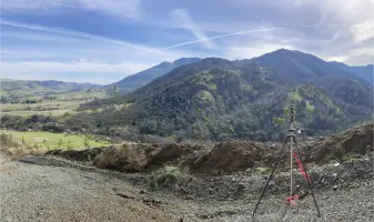
Polaris Land Surveying has built a reputation as a trusted full-service surveying and mapping firm with decades of combined experience across diverse projects. Our team of licensed professionals specializes in boundary surveys, topographic mapping, ALTA surveys, and advanced GPS control networks, serving individuals, public agencies, and private companies throughout California. Certified as MBE/WBE/UDBE/SB, we support larger firms in meeting project diversity goals while maintaining rigorous standards of accuracy and efficiency.Headquartered in Carmel Valley, our work spans municipal infrastructure, environmental restoration, and complex boundary disputes, reflecting our commitment to technical excellence and client collaboration. Our principals hold leadership roles in the California Land Surveyors Association, underscoring our industry authority and dedication to advancing professional standards.
Services
Boundary Surveys
ALTA Surveys
Topographic Mapping
Construction Staking
GPS Control Networks
FEMA Elevation Certificates
Parcel Subdivisions
Expert Witness Services
ADA Compliance Surveys
GIS Data Acquisition
Highlights and features
- We offer 20+ years of experience in municipal, utility, and environmental surveying projects.
- Our team holds leadership roles in the California Land Surveyors Association.
- We provide certified GPS control network surveys and aerial photogrammetric control.
- MBE/WBE/UDBE/SB certifications ensure compliance with project diversity requirements.
- Our principals have completed landmark projects like the Monterey Peninsula Water Supply Pipeline.
Associations and certifications
- MBE
- WBE
- UDBE
- SB
Services
Boundary Surveys
Our boundary surveys precisely determine property lines through title research and field verification. Using advanced equipment, we locate monuments and encroachments to create legally defensible maps. Clients receive detailed plats that prevent disputes and support real estate transactions.
ALTA Surveys
We conduct ALTA/NSPS surveys meeting strict standards for commercial property transactions. These detailed surveys identify easements, improvements, and zoning compliance issues required by title companies. Our reports help lenders and buyers mitigate risks associated with land acquisitions.
Construction Staking
Our staking services guide infrastructure projects with millimeter accuracy. We translate engineering plans into physical markers for roads, utilities, and buildings. Recent projects include highway improvements and wastewater treatment facilities across Central California.
GPS Control Networks
We establish high-precision GPS networks serving as reference frameworks for large-scale projects. These networks support aerial mapping, pipeline alignment, and environmental monitoring efforts requiring consistent coordinate systems across expansive areas.
Expert Witness Services
Our licensed surveyors provide court testimony in boundary disputes and land use cases. We prepare exhibit maps and analyze historical records to clarify parcel legality for attorneys and property owners involved in litigation.
People
Lynn Kovach
Founder & Principal Surveyor
With 30+ years of experience, Lynn founded Polaris to deliver exceptional surveying services. She mentors professionals, serves on the California Board of Surveyors, and specializes in complex boundary resolution for municipal and utility projects.
Kathy Nitayangkul
Principal Surveyor
A certified Federal Surveyor with 20+ years in hydrology and boundary disputes, Kathy leads complex land transactions. She holds a Master's in Coastal Watershed Science and serves as CLSA Treasurer, advancing industry standards.
Ryder Kovach
Principal Surveyor
Licensed in 2022, Ryder specializes in stability monitoring and ranch boundary surveys. As Monterey Bay CLSA President, he promotes technological innovation while maintaining traditional surveying excellence across large-scale projects.
Hans Haselbach
GPS Specialist
Hans provides technical expertise for GPS implementations and geomatic technology solutions. His 25+ years of experience ensure accurate data collection and troubleshooting for Polaris' most complex geospatial challenges.
Aubrianne Culbertson
Survey Technician
As a licensed LSIT, Aubrianne supports field operations and data processing for boundary and topographic surveys. She contributes to diverse projects ranging from ADA compliance assessments to environmental restoration mapping.
Questions
What survey types do you specialize in?
We specialize in boundary surveys, ALTA/NSPS maps, topographic mapping, construction staking, and GPS control networks for public and private clients.
Are you certified for government projects?
Yes, we're certified as MBE/WBE/UDBE/SB, helping prime contractors meet diversity goals for public infrastructure projects across California.
How do I request a survey?
Contact us at (831) 659-9564 to discuss your project needs. Our team will assess requirements and provide a customized scope of work.
Do you handle environmental surveying?
Yes, we've completed projects at national parks and protected areas, including river restoration and habitat mapping with federal agencies.
Can you assist with legal boundary disputes?
Our licensed surveyors provide expert testimony and exhibit maps for boundary litigation, supported by thorough title research and field evidence.
What geographic areas do you cover?
While based in Carmel Valley, we serve all of Monterey County and frequently work in San Benito, Santa Cruz, and surrounding counties.