Business Details
50+ Years
experience
Professional Surveying Services in Richland, WA
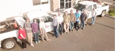
Since 1968, Rogers Surveying has been a trusted provider of professional surveying services in Richland, Washington. Our team of 11 dedicated professionals includes three licensed Land Surveyors with credentials across Washington, Oregon, Idaho, and Montana, as well as a Certified Federal Surveyor (CFedS). We specialize in a comprehensive range of survey types, including cadastral, boundary, topographic, hydrographic, and construction surveys, supported by state-of-the-art equipment like GPS receivers, robotic total stations, and hydrographic tools.With over 50 years of experience, we serve federal agencies, local governments, engineering firms, and private clients, maintaining a reputation for precision, reliability, and timely project delivery. Our commitment to quality is reflected in our repeat clients, on-call contracts, and industry recognition. We prioritize client satisfaction through transparent communication, responsible project management, and adherence to the highest professional standards, ensuring every project meets exacting specifications and budgetary constraints.
Services
Cadastral Surveys
Boundary Surveys
Topographic Surveys
Engineering Surveys
Construction Surveys
Hydrographic Surveys
Subdivisions
Short Plats
Quantity Surveys
Route Surveys
Details
- Year established: 1968
Highlights and features
- We offer over 50 years of experience in professional surveying.
- Our team includes licensed surveyors in Washington, Oregon, Idaho, and Montana.
- We utilize state-of-the-art equipment including GPS and robotic total stations.
- We maintain an outstanding industry reputation for quality and timely service.
- Immediate availability of four fully equipped field survey crews.
Associations and certifications
- Certified Federal Surveyor (CFedS)
What people say
Above and beyond
Helpful document
Top-notch
Recognized in the industry
Excellent performance
Services
Cadastral Surveys
Cadastral surveys precisely define property boundaries and legal descriptions using advanced GPS and field equipment. Our team ensures compliance with state and federal regulations, resolving disputes and supporting land development projects. Clients benefit from accurate documentation for real estate transactions, subdivisions, and title insurance requirements.
Hydrographic Surveys
Hydrographic surveys map underwater terrain and water body characteristics using specialized fathometers and jet boats. This service supports infrastructure projects, environmental assessments, and floodplain management. Clients receive detailed bathymetric data for coastal, riverine, and reservoir applications.
Topographic Surveys
Topographic surveys capture natural and man-made features of land parcels using robotic total stations and GPS technology. These surveys inform engineering designs, construction planning, and environmental studies. Clients gain precise elevation data and contour maps for site development projects.
Construction Surveys
Construction surveys establish accurate layout points for building foundations, roads, and utilities using robotic equipment. Our team ensures projects adhere to design specifications, minimizing costly errors. Clients receive ongoing support for grading, utility installation, and as-built documentation.
Aerial Mapping Control
Aerial mapping control provides high-resolution orthophotos and 3D models using drone technology. This service supports large-scale land assessments, progress monitoring, and volumetric calculations. Clients benefit from rapid data collection over expansive or challenging terrain.
Questions
What types of surveying services do you offer?
We provide cadastral, boundary, topographic, hydrographic, construction, subdivision, ALTA, and GPS surveys using advanced equipment and licensed professionals.
Which areas do you serve?
We operate throughout Washington, Oregon, Idaho, and Montana, with licensed surveyors familiar with regional regulations and terrain.
What equipment do you use?
Our tools include GPS receivers, robotic total stations, hydrographic fathometers, and aerial mapping drones for precise data collection.
How long have you been in business?
Rogers Surveying has delivered professional services since 1968, with over 50 years of experience in public and private sector projects.
Can you handle urgent surveying needs?
We offer four fully equipped field crews available for immediate deployment to meet tight deadlines and project demands.