Business Details
50+ Years
experience
Emergency
services
Your Trusted Partner for Aerial Application & Remote Sensing Solutions
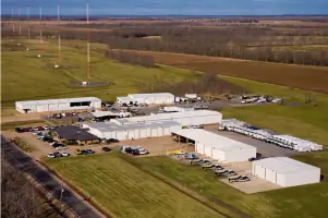
Chem-Air has been a trusted provider of aerial application and remote sensing services since 1973. Under the leadership of owner and president Bart Alexander, we have grown into an industry leader, combining cutting-edge technology with decades of expertise. Our services include aerial application, LiDAR, hydrocarbon detection, fire suppression, and helicopter charter operations. Our team of highly skilled pilots, ground crew, and specialists brings over 100,000 hours of collective flight experience, ensuring precision and reliability in every mission. We utilize advanced DGPS guidance systems, AutoCal II Flow Control devices, and Riegl Vux 240 LiDAR scanners to deliver unmatched accuracy in forestry, oil and gas, and environmental applications. Our FAA-certified helicopter charter services provide tailored solutions for aerial tours, surveys, and passenger transport.We specialize in innovative forest inventory methods, capturing detailed metrics like tree height, crown radius, and stem diameter through high-density LiDAR scanning. Our partnership with AerialOGI has revolutionized hydrocarbon detection, integrating lidar, optical gas imaging, and TDLAS methane lasers into turbine-powered Bell helicopters for single-pass pipeline inspections. We maintain a commitment to safety, efficiency, and technological advancement, serving clients across the southeastern United States. With a focus on family values and customer satisfaction, we deliver actionable data and expert service that exceed industry standards.
Services
Aerial Application
LiDAR Scanning
Hydrocarbon Detection
Fire Suppression
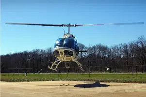
Helicopter Charter
Details
- Year established: 1973
Highlights and features
- We have over 50 years of experience in aerial application and remote sensing.
- Our FAA-certified helicopter charter services ensure regulatory compliance and safety.
- We utilize patented LiDAR technology for comprehensive forest inventory assessments.
- Our pilots and crews bring 100,000+ hours of collective flight experience.
- We integrate multiple detection systems for single-pass pipeline inspections.
Services
Aerial Application
We provide precision aerial application services using DGPS guidance systems and AutoCal II Flow Control devices. Our FAA-certified pilots deliver herbicides, fertilizers, and other treatments across forestry, agricultural, and aquatic environments. With over 50 years of experience, we ensure accurate coverage maps and real-time data transmission for forestry management, pipeline rights-of-way, and row-crop applications.
LiDAR Scanning
Our Riegl Vux 240 LiDAR systems create high-density, colorized point clouds for forestry and construction projects. We capture tree metrics like height, crown radius, and stem diameter without interpolation. This technology enables single-tree inventories and subsidence risk assessments, providing clients with actionable data for forest management and infrastructure planning across large-scale operations.
Hydrocarbon Detection
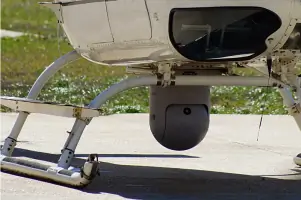
In partnership with AerialOGI, we integrate lidar, optical gas imaging, and TDLAS methane lasers for single-pass pipeline inspections. Our Bell 206B helicopters identify leaks while mapping terrain subsidence risks. Advanced reporting software directly integrates findings into clients' LDAR systems, streamlining leak mitigation processes for oil and gas infrastructure.
Fire Suppression
We deploy helicopters equipped for large-scale fire suppression operations. Our FAA-certified crews utilize water buckets and retardant delivery systems to combat wildfires in remote or inaccessible areas. With decades of aviation experience, we provide rapid response capabilities while maintaining strict safety protocols during emergency operations.
Helicopter Charter
Our FAA Charter Certificate enables customized helicopter services for surveys, passenger transport, and corporate travel. We operate turbine-powered Bell 206B helicopters tailored for scenic tours, industrial inspections, and executive transport. With a focus on safety and reliability, we provide flexible scheduling and mission-specific equipment configurations for business and personal needs.
People
Bart Alexander
Owner and President
Bart Alexander has led Chem-Air since its founding in 1973, growing the family-owned business into an industry leader. He oversees operations that combine advanced aviation technology with over 50 years of collective flight experience to deliver precision aerial services across multiple sectors.
Questions
What aerial services does Chem-Air offer?
We provide aerial application, LiDAR scanning, hydrocarbon detection, fire suppression, and helicopter charter services using FAA-certified aircraft and advanced technology.
How long has Chem-Air been in business?
We have operated since 1973, providing over 50 years of experience in aerial application and remote sensing technologies.
What areas do you serve?
Our primary service area includes the southeastern United States for forestry, oil and gas, and environmental applications.
What makes your LiDAR services unique?
We use Riegl Vux 240 scanners to capture complete forest inventories without interpolation, providing precise metrics for every tree in a stand or plot.
Do you offer emergency response services?
Yes, we provide FAA-certified fire suppression operations using specialized helicopter equipment for rapid wildfire response.
How do you ensure data accuracy?
We utilize DGPS guidance systems, AutoCal II Flow Control devices, and real-time data transmission to guarantee precise application records and coverage maps.