Business Details
39 Years
experience
Expert Utility Mapping & Subsurface Engineering
Inframap has established itself as a leader in infrastructure mapping and utility engineering since 1987. Our team combines advanced technology with deep expertise in geophysics and utility systems to deliver engineering-grade data that mitigates risks in construction projects. We pioneered subsurface utility engineering (SUE) and continue innovating through dedicated R&D, creating proprietary tools when commercial equipment falls short. Our professionals adhere to strict quality standards, following ASCE 38-02 guidelines while maintaining a company-wide safety program that protects both workers and the public. With decades of experience managing complex utility corridors, we provide accurate data that prevents costly delays, design changes, and contractor claims.Our commitment to quality control extends to GIS database development, where we implement centimeter-level accuracy for utility asset management. We serve transportation agencies, defense infrastructure, municipalities, and utility providers across the United States, maintaining a culture where field technicians take personal responsibility for data accuracy. Our patented technologies and standardized procedures ensure consistent results, while comprehensive training programs maintain technical excellence across all service levels.
Services
Subsurface Utility Engineering
3D Utility Mapping
GIS Support Services
Utility Infrastructure Mapping
Geographic Information Systems
Details
- Year established: 1987
Highlights and features
- Pioneered SUE technology since 1987 with continuous R&D innovation
- Certified Technical Locator program ensures field technician expertise
- Patented electromagnetic imaging equipment for challenging conditions
- ASCE 38-02 standard committee participation ensures compliance leadership
- Comprehensive safety program with specialized training certifications
Associations and certifications
- SWAM Certified
What people say
High quality work
Very responsive
Top Notch service
Saved $200,000 on project
Mission-critical infrastructure experts
Services
Subsurface Utility Engineering
Our subsurface utility engineering combines geophysical detection with land surveying to create accurate underground utility maps. This service helps construction planners avoid conflicts through quality level B designating and level A test holes using non-invasive vacuum excavation. We adhere to ASCE 38-02 standards while providing data that reduces project risks and prevents costly delays.
3D Utility Mapping
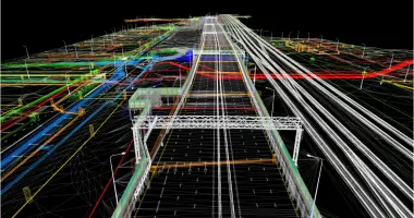
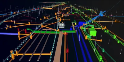
Our 3D utility mapping technology visualizes subsurface infrastructure in three dimensions using proprietary electromagnetic imaging systems. This advanced approach enables better conflict analysis during highway design and construction planning. Our R&D team developed specialized software that works in all soil conditions, providing survey-grade coordinates for improved project coordination and reduced change orders.
GIS Support Services
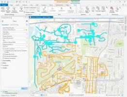
We create and maintain GIS databases with centimeter-level accuracy for utility asset management. Our team develops custom applications for data migration, automation, and quality assurance while maintaining network integrity. These geospatial tools help municipalities and transportation agencies improve excavator safety, enhance network modeling, and resolve inconsistencies in legacy records.
Utility Infrastructure Mapping
Our comprehensive utility infrastructure mapping includes both subsurface and above-ground assets like pole-mounted facilities. We document precise dimensions of vaults and manholes while maintaining as-built records. This service provides complete utility data packages that enhance engineering planning and prevent infrastructure damage during construction projects.
Geographic Information Systems
We specialize in creating utility GIS databases that integrate with existing organizational systems. Our services include schema design, legacy data migration, and quality assurance testing. By linking source documents to geometric objects, we create searchable records that improve maintenance operations and ensure accurate utility network modeling for infrastructure projects.
People
Paul Hayes
Founder, Chief Executive Officer
Paul Hayes founded InfraMap in 1987 and pioneered subsurface utility engineering practices. With decades of industry leadership, he continues driving innovation while maintaining the company's commitment to technical excellence and client satisfaction.
Darlene Siegel
Chief Financial Officer
Darlene Siegel, CPA and CGMA, manages InfraMap's financial operations with extensive experience in corporate finance and accounting. She holds an MBA and ensures financial stewardship that supports the company's technological innovation and growth initiatives.
Simon P. Ellis
Vice President, Field Operations
Simon Ellis leads field operations with responsibility for technical execution and service delivery. He oversees the implementation of standardized procedures while maintaining the company's culture of quality and operational excellence across all projects.
Robin Myrick
Controller
Robin Myrick manages accounting operations and financial reporting for InfraMap. With extensive experience in financial controls and compliance, she ensures accurate financial management that supports the company's engineering services and growth objectives.
Questions
What is InfraMap's core expertise?
We specialize in subsurface utility engineering and 3D utility mapping using advanced geophysical techniques to create accurate infrastructure data for construction projects.
How does 3D utility mapping benefit projects?
Our 3D mapping technology enables better conflict analysis, reduces change orders, and improves coordination between stakeholders through precise subsurface visualization.
What industries do you serve?
We work with transportation agencies, defense infrastructure, municipalities, airports, and utility providers across the United States on infrastructure mapping projects.
How do you ensure data accuracy?
We combine patented electromagnetic imaging equipment with certified technicians, standardized procedures, and quality control checks at every project stage.
What safety programs do you maintain?
Our comprehensive safety program includes hazardous material training, confined space entry, and equipment-specific certifications to protect workers and the public.
How long have you been in business?
InfraMap has provided utility mapping services since 1987, pioneering subsurface utility engineering practices and developing patented technologies.