Business Details
Emergency
services
Expert Engineering Services in Toledo
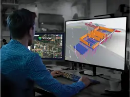
Ground Penetrating Radar Systems (GPRS) has established itself as a leader in subsurface utility locating and infrastructure mapping since its founding. With over 500 SIM-certified project managers nationwide, we combine advanced technologies like ground penetrating radar (GPR), electromagnetic locators, and 3D laser scanning to deliver 99.8% accuracy in subsurface data collection. Our team specializes in preventing subsurface damage through precise utility mapping, concrete scanning, and video pipe inspections, serving architects, engineers, and construction professionals across the United States. We maintain rigorous industry certifications, including NASSCO PACP, LACP, and MACP standards, ensuring compliance with the highest quality benchmarks. Our proprietary SiteMap platform provides real-time GIS-based infrastructure visualization, enabling clients to manage projects with unparalleled precision.Backed by a Rapid Response program and a commitment to 100% subsurface damage prevention, GPRS delivers field-to-finish solutions that integrate seamlessly with BIM modeling and facility management systems. Our expertise extends to critical infrastructure sectors including power generation, environmental due diligence, and electric vehicle charging installations. Through continuous innovation in subsurface investigation methodology, we empower clients to reduce project risks, eliminate rework, and maintain operational safety. Our nationwide presence ensures timely mobilization for emergency services while maintaining consistent quality across all engagements. By combining technical excellence with comprehensive data management, GPRS remains at the forefront of subsurface utility engineering solutions.
Services
Utility Locating
Concrete Scanning
3D Laser Scanning
Video Pipe Inspection
Leak Detection
As-Built Creation
Drone Imagery
Virtual Tours
Floor Plan Creation
SiteMap GIS Platform
Highlights and features
- We offer 99.8% accurate subsurface utility mapping using multiple complementary technologies
- Our nationwide network of 500+ SIM-certified project managers ensures consistent quality
- Patented SiteMap platform provides real-time GIS-based infrastructure visualization
- NASSCO-certified video pipe inspection services with detailed defect reporting
- Rapid Response program mobilizes teams within hours for emergency projects
Associations and certifications
- NASSCO
- SIM-certified
Services
Utility Locating
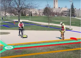
Our utility locating service identifies underground infrastructure with 99.8% accuracy using ground penetrating radar and electromagnetic locators. We map public and private utilities including water, sewer, electrical, and communication lines. Deliverables include georeferenced digital maps and SiteMap platform integration for construction planning and excavation safety.
Concrete Scanning
Concrete scanning uses GPR technology to detect rebar, post-tension cables, and conduits in structural slabs. Our non-destructive testing identifies hazards before coring or cutting operations. The Green Box Guarantee ensures 99.8% accuracy for commercial and industrial applications while maintaining active worksite safety.
3D Laser Scanning
3D laser scanning creates millimeter-accurate digital twins of facilities and infrastructure. We use Leica scanners and Matterport technology to generate BIM models, as-built drawings, and virtual tours. Deliverables support MEP coordination, clash detection, and facility management across architecture and engineering projects.
Video Pipe Inspection
NASSCO-certified video pipe inspections use robotic crawlers and lateral launch cameras to assess sewer infrastructure. We identify cross bores, structural defects, and blockages while generating interactive WinCan reports. Our defect mapping integrates with utility data for comprehensive subsurface visualization.
Leak Detection
Acoustic leak detection services identify pressurized water line failures using specialized microphones and correlators. We combine leak detection with CCTV inspections and utility locating to prevent water loss. Our subsurface investigation methodology achieves 99.8% accuracy in municipal and industrial water infrastructure assessments.
Questions
How does GPRS locate utilities?
GPRS uses SIM Subsurface Investigation Methodology combining ground penetrating radar, electromagnetic locators, and RTK positioning to achieve 99.8% accuracy in utility mapping.
What tools are used for utility locating?
We employ ground penetrating radar (GPR) for non-conductive materials, electromagnetic locators for conductive lines, and radio frequency transmitters as part of our comprehensive SIM process.
Why supplement 811 utility locates?
811 services only mark public utilities. GPRS locates private and unregistered utilities missing from 811 data to prevent costly subsurface damage.
What happens if a utility line is struck?
Utility strikes risk serious injury, service disruptions, environmental hazards, and legal liability. Our 99.8% accurate locating prevents these incidents.
What is NASSCO certification?
NASSCO PACP, LACP, and MACP certifications ensure standardized defect coding and reporting for sewer infrastructure assessments using video pipe inspection technology.
Videos