
Business Details
39 Years
experience
Trusted Infrastructure Engineering & NDE Services
Infrasense is a client-focused consulting firm specializing in nondestructive evaluation (NDE) of infrastructure, with nearly four decades of experience delivering data-driven solutions. Founded in 1987 with support from National Science Foundation (NSF) SBIR grants, we combine scientific precision with practical application to assess bridges, pavements, tunnels, and transportation systems. Our expertise spans advanced technologies like ground penetrating radar, infrared thermography, and subsurface utility mapping, serving public and private sectors across 50 U.S. states and internationally. Backed by 160+ years of collective team experience, we prioritize actionable insights, regulatory compliance, and cost-effective asset management strategies.Our client-centric approach ensures tailored solutions for infrastructure challenges, supported by rigorous research, proprietary software development, and validated methodologies. With offices in Massachusetts and North Carolina, we deliver geospatially referenced data that integrates seamlessly into GIS systems, enabling strategic maintenance planning and network-level assessments. Recognized for innovation, we hold patents in NDE techniques and maintain leadership roles in industry standards development.

Services
Bridge Deck Scanning
Concrete Structure Analysis
Pavement Evaluation
Subsurface Utility Mapping
Aerial Thermography
Details
- Year established: 1987
Highlights and features
- 40 years of pioneering NDE expertise with NSF-backed innovation
- Proprietary multi-method technologies ensure 97%+ data accuracy
- Nationwide service with 120M+ sq ft bridge deck evaluations
- Client-focused approach with 15+ year agency partnerships
- Geospatially integrated reporting for seamless asset management
What people say
Deep technical expertise
Proven track record
Cost-effective solutions
Accurate data delivery
Long-term partnerships
Services
Bridge Deck Scanning
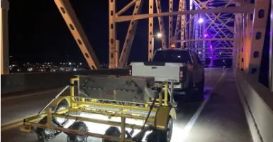
Advanced NDE using ground penetrating radar and infrared thermography to detect delamination, spalling, and corrosion in bridge decks. Our highway-speed assessments map structural defects with GPS precision, enabling targeted repairs and budget optimization. Clients receive GIS-compatible condition maps and quantified deterioration analysis for rehabilitation planning.
Concrete Structure Scanning
Comprehensive evaluation of concrete structures using multi-technology NDE. We map subsurface defects, measure thickness, and locate embedded utilities in parking garages, tunnels, and buildings. Our reports include CAD-compatible maps and repair quantity estimates, minimizing destructive testing while ensuring structural integrity assessments meet ASTM standards.
Pavement Structure Evaluation
High-speed pavement assessment combining GPR and deflection testing to measure layer thickness and structural capacity. We provide cross-section analysis reports and network-level condition data, supporting agencies in optimizing maintenance schedules and extending pavement life through data-driven decision-making.
Subsurface Site Investigation
Integrated geophysical methods including electrical resistivity and electromagnetic conductivity for subsurface characterization. Our SUE services identify utilities, contamination boundaries, and geological features with Level B accuracy, reducing excavation risks and supporting foundation design for complex infrastructure projects.
Aerial Imaging
Fixed-wing and drone-based infrared thermography for large-scale infrastructure assessment. We deliver high-resolution thermal and visual imaging of bridge decks and roadways, with automated defect mapping and GPS-referenced data that reduces inspection costs by 70-80% compared to traditional methods.
People
Adam Carmichael
President
Civil engineer with 15+ years in NDE leadership, managing client relationships and operations. Holds WPI engineering degree and Babson MBA. Specializes in strategic growth and technical project oversight for infrastructure assessments.
Ken Maser
Founder and Senior Principal
Internationally recognized NDE expert with MIT PhD and 100+ publications. Pioneered bridge evaluation techniques used nationwide. Supervised 1,000+ bridge decks and 15,000 lane-miles of pavement assessments during his career.
Evan Guarino
Principal Engineer
Civil engineer with WPI degrees and 12+ years in NDE project management. Collected data on 1,100+ bridge decks and 7,000+ pavement miles. Focuses on marketing integration and technical field operations.
Keith Sorota
Principal Geophysicist
UMass Lowell graduate with 18 years in subsurface utility engineering. Leads SUE department using GPR from 40MHz-2.6GHz. Specializes in void detection and concrete assessment, with guest lecturing experience at Tufts University.
Ralf Birken
Principal Engineer
Geophysical engineer with Arizona PhD and 20+ years in NDE. Holds 7 patents and has authored 4 book chapters. Focuses on pavement inspection and subsurface utility engineering, with expertise in data analysis and field operations.
Questions
What infrastructure types do you assess?
We specialize in bridges, pavements, tunnels, parking structures, and transportation systems using nondestructive evaluation technologies.
How do you ensure data accuracy?
Our multi-method approach combines GPR, thermography, and deflection testing with GPS-referenced analysis to validate findings across technologies.
Can you work with existing management systems?
We provide GIS/CAD-compatible reports that integrate directly into bridge and pavement management platforms for seamless planning.
What geographic areas do you cover?
We operate nationwide with international experience in Canada, Europe, Asia, Australia, and the Middle East.
How quickly can projects be completed?
Vehicle-mounted systems enable highway-speed data collection, completing bridge deck assessments in hours rather than weeks required for manual methods.
Do you offer emergency assessments?
While we don't provide emergency services, our rapid deployment teams can schedule priority assessments within standard business hours.