Business Details
15 Years
experience
Expert Hydrographic Survey & Geospatial Data Processing Services
Geomatics Data Solutions has established itself as a leader in spatial data processing and hydrographic survey services. With over 50 years of combined experience among our professionals, we specialize in transforming raw geospatial data into actionable information through innovative workflows. Our expertise spans bathymetric lidar, multibeam echosounder systems, and cable route charting, serving clients across marine and terrestrial environments. We prioritize efficiency through automation while maintaining rigorous quality control standards. Our team develops customized solutions for data acquisition, processing, and visualization, utilizing advanced technologies like Leica Chiroptera II lidar systems and Reson SeaBat T20-P multibeam sonars.We provide end-to-end services from project planning to final deliverables, or targeted support for specific workflow components. Our capabilities include creating digital elevation models, 3D visualizations, and specialized GIS/CAD products tailored to client needs. With operations in both the United States and Canada, we serve diverse industries requiring precise geospatial analysis. Our commitment to staying at the forefront of technological advancements ensures clients receive cost-effective, high-quality solutions. We collaborate closely with clients to develop sustainable in-house workflows while maintaining flexibility to adapt to evolving project requirements.
Services
Multibeam Charting
Lidar Surveying
Cable Route Mapping
Workflow Design
Data Processing
Details
- Year established: 2011
Highlights and features
- We offer 50+ years combined experience in spatial workflow development
- We provide end-to-end processing solutions for marine and terrestrial data
- Our team specializes in seamless land-water dataset integration
- We maintain cutting-edge lidar and multibeam sonar technologies
- Our workflow automation reduces client costs while maintaining quality
Services
Multibeam Charting
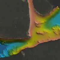
Our multibeam charting services utilize advanced sonar technology to create detailed underwater topographic maps. We process data from multiple manufacturers' systems to produce accurate bathymetric charts meeting IHO standards. This service supports dredging projects, pipeline route planning, and marine infrastructure development through precise depth measurements and seabed analysis.
Lidar Surveying
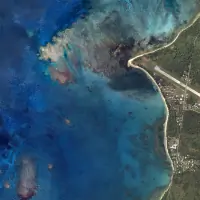
We operate Leica Chiroptera II and HawkEye III lidar systems for simultaneous topographic and bathymetric data collection. Our 17 years of experience enables seamless land-water elevation modeling using four-band imagery. This service provides high-resolution elevation data for coastal zone management, floodplain mapping, and infrastructure planning applications requiring vertical accuracy.
Workflow Design
Our team develops customized data processing workflows that automate repetitive tasks while maintaining quality control checkpoints. We integrate GIS, CAD, and specialized software to streamline large dataset management. This service reduces processing time by up to 40% while ensuring consistent output quality across diverse sensor data formats and project requirements.
Cable Route Mapping
We provide comprehensive charting solutions for telecommunications and power cable installations. Our services include pre-survey background charts, real-time vessel charting, and final as-laid documentation. We combine multibeam bathymetry with geophysical data to identify optimal routes and potential hazards for projects ranging from 25km island links to transoceanic routes.
Data Processing
We transform raw sensor data into actionable deliverables including digital elevation models, orthomosaics, and GIS layers. Our processing capabilities handle datasets from multiple sources simultaneously, maintaining consistent vertical datums across land-water interfaces. We produce standardized formats like S-57 files and customized visualizations for coastal modeling and resource management applications.
Questions
What services does Geomatics Data Solutions offer?
We specialize in multibeam charting, lidar surveying, cable route mapping, workflow design, and comprehensive data processing for marine and terrestrial projects.
What geographic areas do you serve?
We operate from Hillsboro, OR and Calgary, AB, with project experience spanning coastal regions, transpacific routes, and continental infrastructure projects.
What technologies do you use for data collection?
We utilize Leica Chiroptera II/HawkEye III lidar systems and Reson SeaBat T20-P multibeam sonars, while maintaining compatibility with other manufacturers' sensor data formats.
How do you ensure data quality?
Our workflows incorporate automated processing with manual quality checkpoints, maintaining IHO standards for hydrographic surveys and using industry-leading software for data validation.
Can you handle large-scale projects?
Yes, our team has processed data for over 2400 km of coastal planning projects and transoceanic cable routes, with secure handling of large-volume datasets.