Business Details
Professional Land Surveying Services in Glastonbury, CT
North By Northeast is a professional surveying firm based in Glastonbury, Connecticut. We specialize in land surveying, hydrographic surveys, laser scanning, and structural monitoring, serving clients across Connecticut, Massachusetts, and New York. Our team utilizes advanced technologies like Leica scanning products and the BLK360 system to deliver precise data for complex projects. We have extensive experience in mapping, facility documentation, and infrastructure analysis, including transmission towers, wastewater treatment plants, and transportation corridors. Our work supports architects, engineers, and developers in understanding as-built conditions and planning future projects.We prioritize accuracy in merging hydrographic and topographic data, as demonstrated in canal siltation studies and shoreline inventories. Our services also include right-of-way mapping, easement acquisition, and 3D modeling of industrial facilities. We maintain professional licenses in three states and collaborate with industry associations to stay at the forefront of surveying standards. Our commitment to technical excellence ensures clients receive reliable data for decision-making. With decades of combined experience, we approach every project with methodical precision and client-focused solutions.
Services
Land Surveying
Laser Scanning
Hydrographic Surveys
Structural Monitoring
Facility Mapping
Highlights and features
- Licensed professionals in Connecticut, Massachusetts, and New York
- Advanced Leica BLK360 scanning technology for accurate 3D modeling
- Proven expertise in merging hydrographic and topographic data sets
- Comprehensive facility mapping for complex industrial structures
- Decades of experience with transportation, energy, and municipal projects
Services
Land Surveying
We conduct precise land boundary surveys using traditional and digital methods. Our services include title research, monumentation, and mapping for property development and legal documentation. Clients receive accurate data for zoning compliance, construction planning, and land transactions.
Laser Scanning
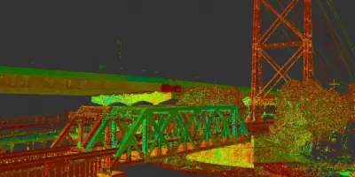
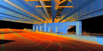
Our Leica BLK360 scanning system captures detailed 3D data of structures and infrastructure. This technology creates precise digital twins for engineering analysis, facility management, and historical documentation. Applications include transmission tower modeling and industrial plant surveys.
Hydrographic Surveys
We collect underwater topographic data using portable sonar systems. Our surveys support dredging projects, environmental assessments, and infrastructure inspections. Data integration with terrestrial surveys provides comprehensive site analysis for coastal and inland water projects.
Structural Monitoring
Our monitoring systems track structural movements over time. We use precision instruments to detect settlement, vibration, and stress in buildings, bridges, and industrial facilities. Clients receive actionable data for maintenance planning and safety compliance.
Facility Mapping
We create detailed spatial records of existing facilities using laser scanning and photogrammetry. Our deliverables include CAD models and GIS-integrated data for facility management, renovation planning, and regulatory compliance in industrial and commercial settings.
Questions
What geographic areas do you serve?
We operate primarily in Connecticut, Massachusetts, and New York, with project experience across the Northeastern United States.
What technologies do you use for surveys?
We employ Leica scanning systems, BLK360 technology, GPS mapping, and traditional surveying equipment for comprehensive data collection.
Can you handle both land and underwater surveys?
Yes, we offer integrated terrestrial and hydrographic surveying capabilities for complete site analysis.
What industries do you work with?
Our clients include energy providers, transportation agencies, industrial facilities, and commercial developers requiring precise spatial data.
Are your surveyors licensed?
Our professionals hold active licenses in Connecticut, Massachusetts, and New York for legal surveying practice.
How do you ensure data accuracy?
We use redundant measurement techniques, statistical analysis, and cross-validation between different surveying methods to guarantee precision.