Business Details
50+ Years
experience
Your Trusted Partner for Geomatics Solutions
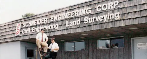
Schneider Geomatics has built a legacy of excellence rooted in over six decades of dedicated geomatics service. As a family-owned business, we prioritize quality, client partnerships, and risk reduction for land, infrastructure, and facility projects. Our history began in 1962 with Vincent Schneider Geomatics, a licensed land surveyor and engineer, who established the foundation for our Indianapolis-based operations. Over the years, we expanded through strategic acquisitions, including Providence Land Group in 2023 and Roger Ward Engineering in 2024, enhancing our expertise in surveying, civil engineering, and sustainable design. Our leadership team, including third-generation owners Barry and Victoria Schneider Geomatics Temple, upholds core principles of service to clients, employees, and the community.We integrate advanced geospatial technology and GIS solutions to deliver precise, client-focused outcomes. With offices across Indiana and the Great Lakes region, we serve government, commercial, and private clients with tailored engineering and surveying services. Our culture emphasizes integrity, innovation, and long-term relationships, ensuring projects meet technical and sustainability standards. Recognized for our growth investments and industry leadership, we remain committed to evolving with client needs while maintaining our founding values. This enduring approach positions us as a trusted partner for complex geomatics challenges nationwide.


Services
Land Surveying
Civil Engineering
GIS Services
Utility Planning
Site Design
Municipal Engineering
Construction Staking
Boundary Surveys
Sustainable Design
Geospatial Solutions
Details
- Year established: 1962
Highlights and features
- Over 60 years of experience in geomatics and surveying
- Family-owned with a legacy of integrity and client focus
- Comprehensive services spanning surveying, GIS, and civil engineering
- Advanced technology for precise, efficient project outcomes
- Strategic acquisitions expanding regional expertise and capabilities
Services
Land Surveying
Our land surveying services provide precise boundary, topographic, and ALTA surveys for residential, commercial, and industrial clients. We utilize advanced equipment and methodologies to ensure accuracy for property development and legal documentation. With decades of regional expertise, we support projects requiring detailed spatial data and compliance with local regulations.
Civil Engineering
We deliver civil engineering services including site design, municipal infrastructure planning, and sustainable development consulting. Our team specializes in utility planning, stormwater management, and construction management for public and private sectors. Backed by 25+ years of experience, we ensure projects meet technical standards while optimizing functionality and environmental considerations.
GIS Services
Our GIS services integrate mapping, data analysis, and e-government solutions to enhance resource management and decision-making. We develop customized geospatial tools for clients in utilities, urban planning, and environmental sectors. With industry-leading technology, we transform complex data into actionable insights for efficient project execution.
Utility Planning
We specialize in utility planning for water, wastewater, and stormwater systems, ensuring reliable infrastructure for growing communities. Our engineers design cost-effective solutions that comply with regulatory standards while minimizing environmental impact. Services include feasibility studies, permitting, and construction oversight for municipal and industrial clients.
Sustainable Design
Our sustainable design services focus on eco-friendly site development, LEED-certified projects, and low-impact construction practices. We collaborate with architects and developers to create energy-efficient solutions that balance growth with environmental stewardship. Expertise includes green infrastructure and renewable resource integration for long-term client value.
People
Barry Schneider
Chairman of the Board
Barry Schneider Geomatics leads the board with an analytical engineering approach, upholding the family legacy of service to clients, employees, and the community through strategic business decisions.
Victoria Schneider Temple
Director
Victoria Schneider Geomatics Temple combines legal expertise and human resources experience to guide corporate strategy, maintaining the firm's commitment to integrity and client-focused service since joining the board.
Raul Zavaleta
Director
Raul Zavaleta contributes engineering expertise and an external business perspective to the board, supporting innovation and operational excellence across Schneider Geomatics' expanding service areas.
Tom Mahon
President
Tom Mahon, a licensed professional surveyor, oversees daily operations with a focus on technical excellence and client satisfaction, leveraging decades of experience in geomatics and engineering leadership.
Matt Bouwie
Vice President, Finance
Matt Bouwie manages financial operations with expertise in fiscal management and business strategy, ensuring sustainable growth and operational efficiency for Schneider Geomatics' third-generation enterprise.
Questions
What services does Schneider Geomatics Geomatics offer?
We provide land surveying, civil engineering, GIS solutions, utility planning, and sustainable design services for government, commercial, and private clients across Indiana and the Midwest.
How long has Schneider Geomatics Geomatics been in business?
Founded in 1962 as Schneider Geomatics Engineering Corporation, we have over 60 years of experience in geomatics, surveying, and engineering services.
Is Schneider Geomatics Geomatics a family-owned business?
Yes, we are a third-generation family-owned company, with leadership from the Schneider Geomatics family and a board that includes Barry and Victoria Schneider Geomatics Temple.
What areas does Schneider Geomatics Geomatics serve?
We serve Indianapolis, Vincennes, Broad Ripple District, Northwest Indiana, and the Great Lakes region, with strategic acquisitions expanding our regional expertise.
What makes Schneider Geomatics Geomatics different from competitors?
Our combination of family-owned values, advanced geospatial technology, and decades of regional experience ensures tailored, client-focused solutions for complex projects.
Does Schneider Geomatics Geomatics handle large-scale projects?
Yes, we manage large-scale infrastructure, municipal, and industrial projects using comprehensive engineering and surveying services backed by 60+ years of expertise.