
Business Details
50+ Years
experience
Emergency
services
Your Trusted Partner for Construction Surveying Solutions
Founded in 1972, Wilson & Associates, P. C has established itself as a leader in construction surveying, geomatics, and advanced technology solutions. Our team of over 30 professionals combines decades of experience with cutting-edge tools like LiDAR scanning, BIM modeling, and 3D machine control to deliver precise data for transportation, commercial, and residential projects. With offices in Franklin, Johnson City, and Cookeville, Tennessee, we serve clients across the Southeast, prioritizing accuracy, efficiency, and client collaboration. Our commitment to innovation is evident in pioneering work with TDOT on 3D constructability reviews and utility coordination, ensuring projects meet deadlines and exceed quality standards. We emphasize teamwork, humility, and accountability, treating employees as family and clients as partners.Our expertise in subsurface utility engineering, dimensional analysis, and virtual design construction has supported billions in infrastructure development, including emergency bridge replacements and large-scale industrial facilities. By integrating traditional surveying with modern technology, we reduce rework, enhance safety, and streamline project timelines. Our clients benefit from tailored solutions, rapid mobilization, and a proven track record in complex projects like the I-65 Bridge Replacement and Wacker Polysilicon Plant. With 50+ years of experience, we remain dedicated to advancing industry standards while maintaining personalized service.
Services
Transportation Construction
Data Modeling
Utility Coordination
Subsurface Utility Engineering
BIM Modeling
Virtual Design Construction
Dimensional Analysis
DOT Route Surveying
Terrestrial LiDAR Scanning
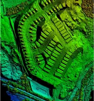
Aerial LiDAR Scanning
Details
- Year established: 1972
Highlights and features
- We have over 50 years of experience in construction surveying and geomatics.
- Our team utilizes advanced LiDAR technology for high-accuracy data collection.
- We serve TN, NC, KY, SC, VA, AL, MS, and GA with rapid mobilization.
- Our services reduce rework and delays through precise pre-construction analysis.
- We maintain a client-centric approach with personalized project support.
Services
Transportation Construction
Our transportation construction services provide precise surveying and staking for roadways, bridges, and utilities. Using LiDAR and 3D modeling, we ensure accurate layouts to streamline project execution. Clients benefit from reduced delays and compliance with DOT standards.
BIM Modeling
BIM modeling generates detailed digital twins for construction projects, enhancing collaboration and clash detection. Our models integrate real-world data to improve design accuracy. This reduces rework and supports informed decision-making throughout the project lifecycle.
Subsurface Utility Engineering
Subsurface Utility Engineering identifies underground utilities to prevent conflicts during construction. We use SUE standards and geophysical methods to map utilities, minimizing risks. This ensures safer excavation and avoids costly delays.
Terrestrial LiDAR Scanning
Terrestrial LiDAR scanning captures high-resolution 3D data for as-built documentation and dimensional analysis. This technology reduces field time and improves accuracy. It supports BIM integration and renovation planning with millimeter-level precision.
Virtual Design Construction
Virtual Design Construction simulates project phases to identify design conflicts before construction. Our VDC process enhances coordination and sequencing. This leads to fewer change orders and more efficient project delivery.
People
Joey C Wilson II
President & CEO
Joey Wilson leads Wilson & Associates, P. C with over 25 years of experience in civil engineering and surveying. He specializes in DOT projects and 3D modeling, holding PE and PS licenses. Joey prioritizes innovation and client collaboration.
Jonathan Bailey
Vice President & COO
Jonathan Bailey oversees construction survey services, managing teams in LiDAR and machine control. With expertise in utility coordination, he ensures projects meet deadlines while maintaining technical excellence across complex infrastructure.
Jon Slemp
Vice President & CPO
Jon Slemp directs survey design services, focusing on residential and commercial land development. His work includes boundary surveys and platting, leveraging LiDAR to enhance accuracy and reduce project timelines.
Justin Wilson
Executive Vice President & CCO
Justin Wilson leads sales and estimating, supporting clients in transportation and industrial projects. He emphasizes strategic partnerships and tailored solutions to align with client goals and project requirements.
Sean McGowan
General Manager
Sean McGowan manages professional surveying services, specializing in boundary and topographic surveys. With a PE and PS license, he ensures compliance and precision for commercial and residential developments.
Questions
What services does Wilson & Associates offer?
We provide construction surveying, LiDAR scanning, BIM modeling, utility coordination, and subsurface utility engineering for transportation, commercial, and residential projects.
Which regions do you serve?
We operate across Tennessee, North Carolina, Kentucky, South Carolina, Virginia, Alabama, Mississippi, and Georgia with rapid mobilization.
How does LiDAR scanning benefit projects?
LiDAR captures high-accuracy 3D data to reduce field time, improve design precision, and support BIM integration for as-built documentation.
Can you handle emergency infrastructure projects?
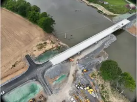
Yes, we specialize in emergency bridge replacements and rapid-response surveys, completing critical tasks like the Nolichucky River bridges in 13 days.
What industries do you support?
We serve transportation, commercial/industrial construction, residential development, and environmental restoration with tailored geomatics solutions.
How do you ensure project accuracy?
We combine traditional surveying with LiDAR, 3D modeling, and SUE standards to verify dimensions, resolve conflicts, and minimize rework.