
Business Details
Your Trusted Partner for Surveying Solutions
Encompass Energy Services has established itself as a leader in geospatial and surveying solutions, delivering innovative services across the United States. With a team of over 300 professionals and a presence in 48 states, we specialize in land surveying, LiDAR mapping, GIS development, UAV drone services, and data management. Our expertise spans critical infrastructure sectors including oil and gas, renewable energy, power transmission, and transportation. Founded on a commitment to technological advancement, we provide tailored solutions that streamline project development from inception to completion.Our strategic network of offices ensures nationwide accessibility, while our investment in cutting-edge tools like Bluesky Development Software and Data Halo maintains our competitive edge. Backed by decades of collective experience, our leadership team prioritizes client success through precision, compliance, and operational excellence. We serve as a trusted partner for complex projects requiring accuracy, scalability, and adherence to evolving industry standards.

Services
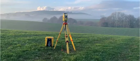
Land Surveying
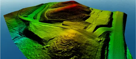
LiDAR Mapping
GIS Development
UAV Drone Services
Data Management
Highlights and features
- We offer nationwide service with 300+ professionals in 48 states
- Our team utilizes proprietary technology like Bluesky Development Software
- We specialize in complex infrastructure projects for energy and utilities
- We provide end-to-end solutions from project inception to completion
- Our leadership team has decades of combined experience in surveying
Services
Land Surveying
Our land surveying services provide precise boundary determination and topographic mapping for infrastructure projects. Utilizing advanced GPS and robotic equipment, we deliver accurate data for pipeline routes, property acquisitions, and construction planning. Our team of licensed surveyors supports oil and gas, renewable energy, and civil engineering clients across the United States.
LiDAR Mapping
LiDAR mapping creates high-resolution 3D models of terrain and infrastructure. Our UAV-mounted systems capture millions of data points per second, enabling detailed volumetric calculations and change detection analysis. This technology supports pipeline monitoring, transmission line inspections, and environmental impact assessments with millimeter-level accuracy.
GIS Development
GIS development integrates geospatial data into actionable intelligence for infrastructure management. Our custom ESRI solutions enable clients to visualize asset networks, track regulatory compliance, and optimize maintenance schedules. We specialize in FME workflow automation to streamline data processing for large-scale energy and utility projects.
UAV Drone Services
UAV drone services provide rapid aerial data collection for large-area projects. Our FAA-certified pilots operate fixed-wing and multirotor platforms equipped with multispectral sensors. This technology supports right-of-way monitoring, construction progress tracking, and environmental compliance reporting while reducing field time by up to 60%.
Data Management
Data management solutions organize geospatial and project information into secure, accessible platforms. Our Data Halo system provides real-time collaboration tools for multi-disciplinary teams, ensuring data integrity across project phases. We implement customized workflows that meet industry standards for pipeline integrity and asset management programs.
People
E. Steven Wright
President
With 40+ years of surveying experience and leadership roles at TransCanada and Williams Transco, Mr. Wright has grown Encompass to 300+ employees. He holds multiple state surveyor licenses and oversees strategic direction for nationwide operations.
Seth Marsolek
Vice President of Corporate Strategy
Seth manages business development and pricing strategies with 17+ years of project management experience. He holds a Business Administration degree from the University of Minnesota and focuses on cross-regional client solutions.
Jerry Sinnott
Vice President of Finance
Jerry oversees financial operations with 40 years of banking experience. He manages financial reporting, project invoicing, and payroll for Encompass' regional managers from his base in Duluth, MN.
Casey Oware
Vice President of Human Resources
Casey leads HR operations with 15 years in energy industry HR. A SHRM-certified professional, she develops systems for payroll, benefits, and safety compliance while maintaining client-focused service standards.
William BJ Whitman
Vice President of Oil and Gas
A third-generation surveyor with 30 years in oil and gas, Mr. Whitman manages Eastern operations. Licensed in six states, he specializes in pipeline surveys and civil infrastructure projects across the East Coast and Midwest.
Questions
What geographic areas do you service?
We operate in all 48 contiguous U.S. states with regional offices from Minnesota to Texas, supporting projects in energy, utilities, and transportation sectors.
What surveying technologies do you use?
Our tools include GPS systems, robotic total stations, LiDAR scanners, and UAV drones. We integrate these technologies with proprietary software like Bluesky Development and Data Halo.
Do you offer GIS development services?
Yes, we provide custom ESRI solutions and FME workflow automation for asset management, regulatory compliance, and spatial analysis tailored to energy and infrastructure clients.
How do you handle large-scale projects?
With 300+ professionals and 100+ survey crews, we deploy regional teams supported by centralized project management systems to maintain quality control across multi-state initiatives.
What industries do you specialize in?
We focus on oil and gas midstream operations, renewable energy projects, power transmission infrastructure, and transportation development with specialized right-of-way expertise.
How can I request project support?
Contact our Duluth headquarters or regional offices to connect with our business development team for customized solutions and resource allocation planning.