
Business Details
47 Years
experience
Professional Land Surveying Services in Corvallis, OR
Founded in 1979, Northstar Surveying has established itself as a trusted provider of professional land surveying services across western Oregon. Our team combines over 100 years of collective experience with cutting-edge technology, including drone-based topography mapping, to deliver precise and efficient solutions for private and public clients. We prioritize client relationships, assigning dedicated project managers to ensure seamless communication and timely execution of every project. Our commitment to integrity and innovation has allowed us to adapt to evolving industry standards while maintaining a family-owned ethos.By integrating advanced tools like GPS and photogrammetric control, we provide cost-effective services tailored to meet the unique demands of each client. Our expertise spans boundary surveys, construction layout, FEMA flood certifications, and subdivision planning, ensuring comprehensive support for residential, commercial, and municipal projects. As we expand into drone services through Northsky Drone Service, we remain focused on fostering long-term partnerships built on reliability and technical excellence.
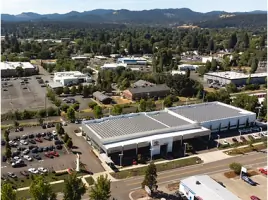
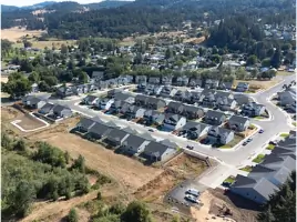
Services
Boundary Surveys
Topographic Mapping
Drone Surveying
Construction Layout
FEMA Flood Certifications
Land Subdivisions
Legal Descriptions
Photogrammetric Control
Details
- Year established: 1979
Highlights and features
- We have over 40 years of experience in land surveying across western Oregon.
- Our team uses drones and GPS technology for accurate topographic mapping.
- We assign expert project managers to ensure timely and efficient service.
- We maintain long-term client relationships through transparent communication.
- Our services cover boundary surveys, subdivisions, and FEMA flood certifications.
Services
Boundary Surveys
Boundary surveys establish property lines and legal descriptions for land parcels. Our team uses advanced GPS and historical records to resolve disputes and ensure compliance with local regulations. Clients rely on our precise measurements for real estate transactions, development projects, and legal documentation.
Drone Surveying
Drone surveying captures high-resolution topographic data for large or complex sites. We deploy FAA-certified pilots and photogrammetry software to create detailed 3D models and contour maps. This technology reduces field time and costs while improving accuracy for construction and environmental projects.
Construction Layout
Construction layout services mark precise locations for buildings, utilities, and infrastructure. Our surveyors work with contractors to translate design plans into physical markers, ensuring alignment with permits and specifications. This prevents costly errors during development phases.
FEMA Flood Certifications
FEMA flood certifications determine a property's flood risk for insurance and compliance purposes. We analyze elevation data and floodplain maps to issue official documentation required by lenders and government agencies for properties in high-risk areas.
Land Subdivisions
Land subdivision services divide larger parcels into smaller lots for residential or commercial use. We handle platting, boundary adjustments, and regulatory approvals to ensure legal compliance. Clients benefit from streamlined processes and expertise in municipal zoning requirements.
People
David L. Schlosser Jr
CEO/President
David has over 40 years of experience in land surveying, holding licenses in Oregon and California. He leads Northstar Surveying with a focus on innovation and client relationships.
Ted Langton
Lead Surveyor
Ted is a licensed surveyor in Oregon and Washington with expertise in construction layout and boundary resolution. He ensures field operations meet Northstar's high standards for accuracy and efficiency.
Bob Cook
Lead Surveyor
Bob specializes in cadastral surveys and legal descriptions, bringing decades of experience in Oregon's land surveying regulations. He mentors junior staff while managing complex client projects.
Mark Gandy
Drone Pilot
Mark operates Northstar's drone fleet for topographic mapping, holding FAA certification. His technical skills support the company's expansion into aerial surveying services.
Rica Schlosser
Public Notary
Rica manages administrative operations and notary services at Northstar. Her role ensures legal documentation meets state requirements for surveying projects.
Questions
What services does Northstar Surveying offer?
We provide boundary surveys, drone mapping, construction layout, FEMA flood certifications, land subdivisions, and legal descriptions for residential and commercial clients.
How long has Northstar Surveying been in business?
Northstar Surveying has served western Oregon since 1979, offering over 40 years of experience in land surveying and mapping services.
Do you use drone technology for surveys?
Yes, we utilize drones for topographic mapping to improve accuracy and reduce project timelines, especially for large or complex sites.
What areas do you serve?
We primarily serve western Oregon, including the Willamette Valley, with expertise in local regulations and terrain conditions.