Business Details
22 Years
experience
Professional Surveying and Mapping Services in Irvine, CA
Saddleback Surveys has been delivering comprehensive surveying, mapping, and geospatial services to public and private sectors since 2004. Our expertise spans utility, construction, and engineering projects, supporting clients from initial design through final approvals. With operations across California and Nevada, we combine over 100 years of combined experience from our licensed professionals with cutting-edge technology like LiDAR, UAV/drone systems, and ground-penetrating radar to ensure precision and efficiency. Our hands-on approach, supervised by Professional Land Surveyors, guarantees quality control and creative solutions tailored to client needs. We maintain strategic partnerships with aerial mapping firms, civil engineers, and architects to offer full-service project support.Safety and compliance are prioritized through field safety plans, injury prevention protocols, and ethics programs. Our team's cross-training enables seamless transitions between office and field work, ensuring continuity and cost savings. Mobile mapping technology collects 1.6 million data points per second, reducing project timelines while maintaining accuracy. We specialize in boundary surveys, ALTA surveys, legal descriptions, and construction staking for residential, commercial, and industrial developments. Our commitment to innovation and client collaboration has solidified our reputation as a trusted partner in complex surveying projects.
Services
Utility Surveys
Construction Staking
Right-of-Way Mapping
LiDAR Scanning
Drone Technology
Boundary Surveys
ALTA Surveys
Legal Descriptions
Mobile Mapping
Ground Penetrating Radar
Details
- Year established: 2004
Highlights and features
- Our team has over 100 years of combined experience in surveying and mapping
- We utilize advanced LiDAR, drone, and mobile mapping technologies
- Hands-on approach with direct supervision by Professional Land Surveyors
- Comprehensive safety and compliance programs for field operations
- Strategic partnerships enable full-service project delivery
Associations and certifications
- Women's Business Enterprise National Council (WBENC)
- California Public Utilities Commission (Woman Owned Business)
- California Unified Certification Program (DBE/SBE)
- Metropolitan Water District of Southern California (SBE)
- Port of Long Beach (SBE)
- San Diego County Water Authority (SBE)
- ISNETworld Grade A contractor
Services
Utility Surveys
Our utility surveys identify underground infrastructure using ground-penetrating radar and traditional methods. We create detailed maps of water, sewer, gas, and electrical systems for construction planning. This service helps prevent costly utility strikes during excavation projects.
Construction Staking
We provide precise construction staking for residential subdivisions, commercial developments, and industrial sites. Our team establishes exact reference points for building foundations, utilities, and roadways. This ensures proper alignment with design plans and regulatory requirements.
LiDAR Scanning
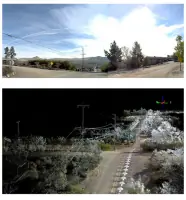
Our LiDAR systems capture 1.6 million data points per second to create high-resolution 3D models. This technology enables rapid topographic mapping and as-built documentation for complex infrastructure projects. Data supports engineering analysis and construction monitoring.
ALTA Surveys
We conduct ALTA/NSPS standard land title surveys for commercial property transactions. Our surveys identify boundary lines, easements, and improvements according to national standards. These detailed maps support title insurance requirements and property acquisitions.
Drone Technology
Our UAV/drone systems capture high-resolution aerial imagery and elevation data. This technology enables efficient site analysis, progress monitoring, and volumetric calculations. Drone data integrates with traditional survey methods for comprehensive project documentation.
Questions
What geographic areas do you serve?
We primarily serve California and Nevada, handling projects from major metropolitan areas to remote locations across both states.
What surveying technologies do you use?
We utilize LiDAR, UAV/drone systems, ground-penetrating radar, terrestrial scanning, and GPS networks for comprehensive data collection.
Are you certified as a woman-owned business?
Yes, we are certified by the California Public Utilities Commission as a Woman-Owned Business Enterprise since 2008.
What construction staking services do you provide?
We offer residential subdivision staking, commercial/industrial layout, tower access road staking, and environmental project staking services.
How does your mobile mapping system work?
Our mobile mapping system collects 1.6 million survey data points per second while traveling at highway speeds, creating detailed 3D models of infrastructure.
What safety programs do you maintain?
We have Field Safety Awareness Plans, Illness and Injury Prevention Programs, and ethics compliance programs for all projects.